Monthly Climate Statement for September 2011
The Queensland Climate Change Centre of Excellence (the centre) considers that the probability of above-median rainfall for the next three-month period (September to November) is higher than normal (50 per cent) for most of Queensland. For the coming summer (November to March), the centre’s experimental long-range outlook (Seasonal Pacific Ocean Temperature Analysis version one (SPOTA-1)) continues to indicate a higher than normal probability of above-median rainfall across Queensland. Read more (PDF, 211K, last updated 10:26AM, 27 September 2011)*
The centre's understanding is based on the current and projected state of the ENSO phenomenon and on factors which alter the impact of ENSO on Queensland rainfall (e.g. the Pacific Decadal Oscillation (PDO)). The centre's outlook for the September to November period is based on an historical analysis of Queensland rainfall and the Southern Oscillation Index (SOI). The centre's long-lead outlook for summer is based on the current sea-surface temperature pattern in the Pacific Ocean with emphasis on sea-surface temperatures in the extra-tropical Pacific.
As at 1 September 2011, the centre notes that sea-surface temperature anomalies in the central equatorial Pacific and other ENSO indicators are approaching La Niña thresholds. The SOI, an atmospheric measure of ENSO, has remained positive now for the last two months (two-month average +5.9). Should positive values of the SOI persist in the coming months and further cooling of sea-surface temperatures occur in the central Pacific, then the chances of a La Niña pattern re-emerging in 2011 will further increase. Although not all international climate models indicate current trends will continue, taking all models into consideration, the Bureau of Meteorology notes there is an expectation that the current trend toward La Niña conditions will continue (see the latest Bureau of Meteorology 'ENSO Wrap-Up' (PDF)*).
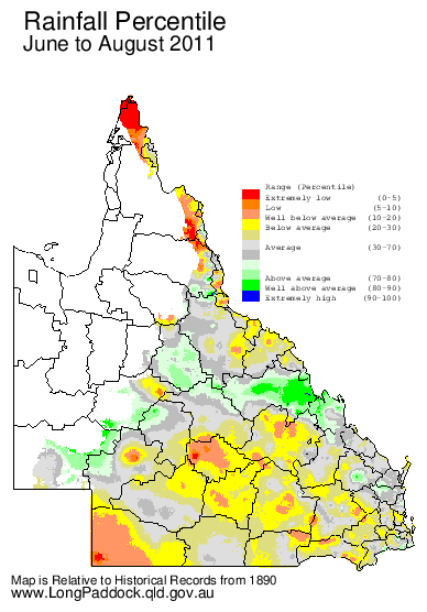
The centre’s assessment of rainfall probabilities for the September to November season is based on consistently positive SOI values which occurred during July (+9.1) and August (+2.6). Rainfall over the last three-month period (June to August) was near median for much of Queensland which was consistent with the centre’s sea-surface temperature pattern in the north Pacific remains consistent with a 'cool phase' of the PDO. The PDO modulates the impact of ENSO on summer rainfall in Queensland, particularly under La Niña conditions. Historically, the ENSO and PDO signals have had the strongest impact on rainfall in north-eastern Queensland and the weakest impact in south-eastern Queensland.
There remains a strong sea-surface temperature gradient across the south west Pacific which is both a remnant of the recent strong La Niña event and current trends in the sea-surface temperature pattern. Based on this strong sea-surface temperature gradient in the sSouth west Pacific and the current 'cool phase' of the PDO, the centre’s experimental SPOTA-1 scheme indicates an increased probability of above-median rainfall for the coming summer (November to March). The centre will continue to monitor sea-surface temperature patterns up until November and revise rainfall probabilities for summer on this basis each month until the start of summer.
There are various approaches used to provide rainfall outlooks based on the above information. These approaches tend to differ in terms of the components of the climate system that are considered and, for this reason, each approach may convey a different outlook, particularly for specific locations.
The centre produces two statistical climate risk assessment schemes:
- the experimental SPOTA-1 scheme integrates sea-surface temperature information, including indices of ENSO and the PDO.
- the SOI phase scheme relies solely on the SOI, an atmospheric measure of ENSO.
The centre's experimental SPOTA-1 scheme provides long-lead probabilities of summer (November to March) rainfall for Queensland from mid-April through to mid-November each year. The sea-surface temperature gradient (west to east) across the South Pacific Convergence Zone (i.e. between eastern Australia and the central Pacific) remains quite positive (+1.24 ºC), a remnant of the recent strong La Niña event. According to the centre's experimental SPOTA-1 scheme, a positive sea-surface temperature gradient across this region is favourable for summer rainfall in Queensland. The SPOTA-1 scheme, which takes this sea-surface temperature gradient into account, as well as the state of the PDO, currently indicates a higher than normal probability of above-median rainfall throughout Queensland over the coming summer.
The centre's SOI phase scheme provides probabilities of rainfall for the coming three-month season based on SOI values over the previous two months. The SOI phase scheme currently indicates that the probability of exceeding median rainfall across most of Queensland is higher than normal (50 per cent) for the next three-month period (September to November). This is discussed further in the centre's Australia's Variable Rainfall poster (PDF, 1.0M, last updated 11:42AM, 24 June 2010)* or the centre's archive of historical rainfall maps).
The centre understands that each of the schemes may have its own particular following. Although such schemes cannot provide outlooks with absolute certainty each year, users of the information who follow a skilful scheme should benefit from doing so in the long-term. Users should consider the historical track record of any scheme and such information is becoming increasingly available. The centre's Long Paddock website provides the historical archive of SPOTA-1 reports and past commentaries on the SOI phase scheme. Users should also consider the wide range of information available each month describing the current state of the ocean/climate system, for example the 'ENSO Wrap-Up (PDF)*'.
For further information, please visit www.LongPaddock.qld.gov.au or contact QCCCE@climatechange.qld.gov.au
* Requires Adobe Reader
