Monthly Climate Statement for February 2012
The Queensland Climate Change Centre of Excellence (the Centre) considers that there is an increased probability of above-median rainfall for Queensland leading into autumn. The Centre’s understanding is based on the current and projected state of the El Niño-Southern Oscillation (ENSO) phenomenon and on factors which alter the impact of ENSO on Queensland rainfall (e.g. the Pacific Decadal Oscillation (PDO)). Read more (PDF, 479K, last updated 11:33AM, 16 February 2012)*
As at 1 February 2012, the Centre notes that Niño 3.4 region sea-surface temperature anomalies in the central equatorial Pacific, a key indicator of the ENSO phenomenon, continue to exceed La Niña thresholds. The Southern Oscillation Index (SOI), an atmospheric measure of ENSO, averaged +14.7 over the last three-month period (to 31 January) and was quite positive (+ 9.6) during January. The recent sea-surface temperature pattern in the North Pacific remains consistent with a ‘Cool Phase’ of the PDO. The PDO modulates the impact of ENSO on summer rainfall in Queensland, particularly under La Niña conditions.
A cool phase of the PDO, coupled with La Niña conditions, is particularly favourable for November to March rainfall in Queensland (see the Centre’s experimental SPOTA-1 scheme which incorporates a measure of both ENSO and the PDO). These conditions are also usually associated with enhanced tropical cyclone activity in the Coral Sea. Most of Australia, including parts of western and southern Queensland, has experienced a wetter than average summer to date. There remains a possibility of a tropical cyclone making landfall in Queensland during February, March or April.
Although a La Niña climate pattern continues to prevail in the Pacific Ocean and it is possible that this pattern may persist through 2012, it is more likely that the current La Niña pattern will weaken and break-down in coming months. Historical evidence suggests that La Niña patterns tend to break down during autumn and most global climate models indicate a return to neutral ENSO conditions during autumn (see the latest Bureau of Meteorology ‘ENSO Wrap-Up (PDF)*’).
There are various approaches used to provide rainfall outlooks. These approaches tend to differ in terms of the components of the climate system that are considered and, for this reason, each approach may convey a different outlook, particularly for specific locations.
The Centre produces two statistical climate risk assessment schemes. They are:
- the experimental SPOTA-1 scheme, which integrates sea-surface temperature information, including indices of ENSO and the PDO, and
- the SOI phase scheme, which relies solely on the SOI, an atmospheric measure of ENSO.
The Centre's experimental SPOTA-1 scheme provides long-lead probabilities of summer (November to March) rainfall for Queensland from mid-April through to mid-November each year. The sea-surface temperature gradient (west to east) across the South Pacific Convergence Zone (i.e. between eastern Australia and the central Pacific) remained positive in October. According to the Centre's experimental SPOTA-1 scheme, a positive sea-surface temperature gradient across this region in October is favourable for summer rainfall in Queensland. The final SPOTA-1 scheme, issued in November, indicated a higher-than-normal (60 to 80 per cent) probability of above-median summer rainfall throughout Queensland.
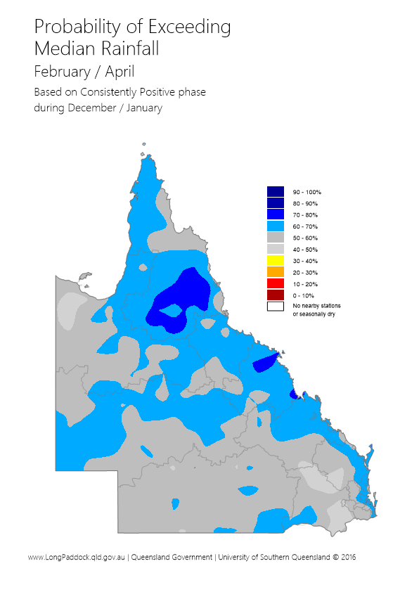
The Centre's SOI phase scheme provides probabilities of rainfall for the coming three-month season based on SOI values over the previous two months. The SOI phase scheme currently indicates that the probability of exceeding median rainfall across most of Queensland is 50 to 70 per cent, which is higher than normal (50 per cent) for the next three-month period (February to April). This analysis is based on the fact that the SOI has remained consistently positive from December to January as discussed further in the Centre's Australia's Variable Rainfall poster (PDF, 9.3M, last updated 03:09PM, 29 July 2016)*, or the Centre's archive of historical rainfall maps).
The Centre understands that each of the above schemes may have their own particular following. Although such schemes cannot provide outlooks with absolute certainty, users of the information who follow a skilful scheme should benefit from doing so in the long-term. Users should consider the historical track record of any scheme, and such historical information is becoming increasingly available.
The Centre's Long Paddock website provides the historical archive of SPOTA-1 reports and past commentaries on the SOI phase scheme. Users should also consider the wide range of information available each month describing the current state of the ocean/climate system, for example the 'ENSO Wrap-Up' (PDF)*.
ENSO influences other climate variables apart from rainfall (e.g. temperature, pan evaporation and vapour pressure). This means that the impact of ENSO on crop or pasture growth can be stronger than on rainfall alone. The impact of ENSO on pasture growth is also dependent upon current pasture condition and soil water status. The Centre’s AussieGRASS model takes these factors into account in producing seasonal pasture growth probabilities.
* Requires Adobe Reader
