Monthly Climate Statement for October 2013
The Science Delivery Division of the Department of Science, Information Technology, Innovation and the Arts (DSITIA) notes that, for the next three-month period (October to December), there is a near-average to slightly lower than average probability of rainfall being above the long-term median. For the coming summer (November to March) there is a higher than normal probability of ‘near-average’ rainfall for much of Queensland with an associated low probability of either widespread ‘dry’ or ‘wet’ conditions. This means that there is a low probability of widespread drought-breaking rainfall across the state for the coming summer. Read more (PDF, 345K, last updated 03:16PM, 15 October 2013)*
Seasonal forecasts are based on the current and projected state of the El Niño-Southern Oscillation (ENSO) phenomenon and on factors which alter the impact of ENSO on Queensland rainfall (e.g. the Pacific Decadal Oscillation (PDO)).
Currently:
-
The Southern Oscillation Index (SOI), a key atmospheric measure of ENSO, rose from a near-zero value (-0.2) in August to a slightly positive value (+4.3) in September). The three-month mean SOI value from July to September 2013 was +3.8, which is within the ENSO-neutral range.
-
The observed sea-surface temperature (SST) anomaly (0.0 ºC) in the key Niño 3.4 region of the central equatorial Pacific remained in the ENSO-neutral range in September.
-
The majority of international global climate models surveyed by the International Research Institute for Climate and Society in the USA, and most models surveyed the Bureau of Meteorology (BoM) ‘ENSO Wrap-Up (PDF)*’ (8 October), suggest that central equatorial Pacific SSTs will remain within the 'ENSO-neutral' range for the remainder of spring and for the coming summer.
For much of Queensland, September 2013 was the warmest on record for mean daily maximum temperature (see BoM Special Climate Statement 46 (PDF)*). According to the BoM Northern Australian temperature outlook, warmer than normal conditions are likely to persist for the rest of this year.
September rainfall was average to below-average across much of the state and extensive areas of inland Queensland, and some northern regions, have experienced extremely-low rainfall over the past twelve months. As at 1 October, over 60 per cent of Queensland was drought declared under State Government processes. Longreach is the most recent regional council area to be at least partly drought declared.
Rainfall Outlook
There are various approaches used to provide rainfall outlooks. These approaches tend to differ in terms of methodology and, for this reason, each approach may convey a different outlook, particularly for specific locations.
DSITIA places emphasis on two statistical schemes:
-
the experimental long-lead SPOTA-1 scheme, which integrates SST information, including indices of ENSO and the PDO; and
-
the SOI Phase scheme, which relies solely on the SOI, an atmospheric measure of ENSO.
The experimental SPOTA-1 scheme provides long-lead probabilities of summer (November to March) rainfall for Queensland from mid-April through to mid-November each year. An updated outlook for summer 2013/14 is now available. This outlook takes into account a monthly ENSO index, as well as an index of March SST anomalies which reflect the current ‘cool’ phase of the PDO. For the coming summer (November to March), the SPOTA-1 scheme currently indicates that there is a higher than normal probability of ‘near-average’ rainfall for much of Queensland with an associated low probability of either widespread ‘dry’ or ‘wet’ conditions. This outlook will be revised in November this year.
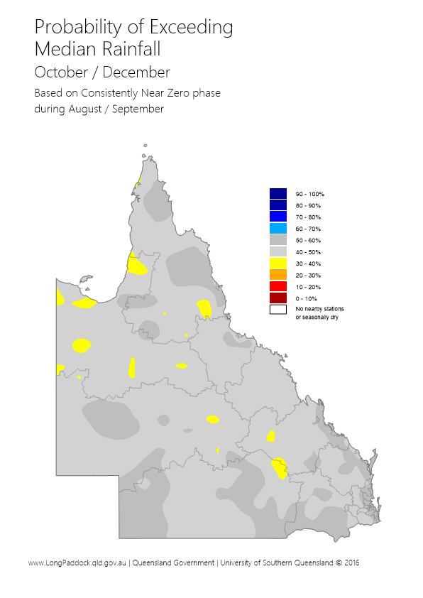
DSITIA’s SOI Phase scheme provides probabilities of rainfall for the coming three-month season based on SOI values over the previous two months. The SOI Phase scheme currently indicates that the probability of above-median rainfall across most of Queensland is 40 to 50 per cent for the next three-month period (October to December). This analysis is based on the SOI being in a ‘Consistently Near-Zero’ phase at the end of September, as discussed further in the Australia's Variable Rainfall poster (PDF, 9.3M, last updated 03:09PM, 29 July 2016)*, or the Department's archive of historical rainfall maps).
Each climate outlook scheme may have its own particular following. Although such schemes cannot provide outlooks with absolute certainty, users of the information who follow a skilful scheme should benefit from doing so in the long-term. Users should consider the historical track record of any scheme, and such information is becoming increasingly available. DSITIA's Long Paddock website provides an archive of SPOTA-1 reports and past commentaries on the SOI Phase scheme.
Whilst DSITIA places emphasis on the SPOTA-1 and SOI-Phase analyses, a much wider range of information from national and international agencies is also considered. DSITIA pays particular attention to the Bureau of Meteorology’s 'ENSO Wrap-Up' (PDF)* which is updated fortnightly on the Bureau’s website.
ENSO influences other climate variables apart from rainfall (e.g. temperature, pan evaporation and vapour pressure). This means that the impact of ENSO on crop or pasture growth can be stronger than on rainfall alone. The impact of ENSO on pasture growth, for example, is also dependent upon current pasture condition and soil water status. DSITIA’s AussieGRASS model takes these factors into account in producing seasonal pasture growth probabilities.
* Requires Adobe Reader
